This is the ninth stage of the Pilgrimage Route of Saint James, one of the most famous pilgrimages in all of Christianity.
This is the ninth stage of the pilgrimage Route of Saint James, one of the most famous pilgrimages in all of Christianity.
Difficulty:
6 to 8 hours walking a day (except Day 2: 11 hours walk, can be shortened), easy routes.
Luggage:
Your luggage is transferred from accommodation to accommodation every day.
Price:
£835 per person, sharing a room
Single room supplement – £160
Hotels:
These are the hotels we would usually book – sometimes they are fully booked and we book an alternative of similar standard.
(please note: hostal in Spanish is an old word for hotel or inn – it is not the same as hostel in English)
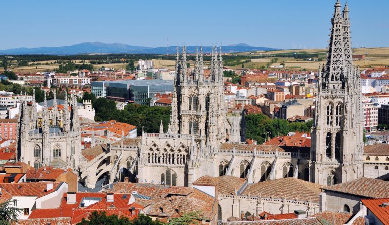
Day 1: Arrival at Burgos (overnight only – dinner not included)
Day 2: Burgos – Castrojeriz, 38.7 km/24.2 miles (possibility of shuttle).
Altitude at departure: 856m/2823ft.
This is a very long section across the Meseta (although, at extra cost, there is the possibility of a transfer to Hornillo del Camino). After the suburbs of Burgos, the route comes to Rabe de las Calzadas, then climbs up to the plateau before redescending to Hornillo del Camino, a timeless village built along its one street. Back up to the plateau, descend to Hontanas, and we arrive at Castrojeriz along a charming valley.
Altitude at arrival: 800m/2640ft, 38.7 kms/24.2 miles, 10 hours.
Day 3: Castrojeriz – Fromista, 25.5 km/15.9 miles.
Altitude at departure: 800m/2640ft.
Up to the plateau again before going down to cross the twelve arches of the Itero bridge which marks the frontier between Burgos and Palencia provinces. We come to the Castille canal which is followed to the entry into Fromista, whose church of St. Martin is a model of Romanesque architecture.
Altitude at arrival: 780m/2574ft, 25.5 kms/15.9 miles, 6 hours 30.
Day 4: Fromista – Carrion de los Condes, 20.5 km/12.8 miles.
Altitude at departure: 780m/2574ft.
To get to Carrion, there are two possibilities: follow either the official, most direct route, or a more rural path beside the Rio Ucieza. In either case a detour via the centre of Villacazar de Sirga is worthwhile. From afar it is impossible not to notice the immense church high above the fields…not without similarities with a certain cathedral at Chartres!
Altitude at arrival: 840m/2772ft, 20.5 kms/12.8 miles, 5 hours 15.
Day 5: Carrion – Moratinos, 30.5 km/19.1 miles.
Altitude at departure: 840m/2772ft.
After Carrion we pass the San Zoilo monastery, before continuing across the ‘paramo’, or ‘desert’; we pass through a number of places before getting to isolated Moratinos, from where there is a transfer for overnight to the interesting town of Sahagun.
Altitude at arrival: 816m/2693ft, 30.5 kms/19.1 miles, 8 hours.
Day 6: Taxi to Moratinos, then Moratinos – Burgos Ranero, 27.9 km/17.4 miles.
Altitude at departure (Sahagun): 816m/2693ft.
Taxi back to Moratinos (although you can start from Sahagun if preferred) and then continue over the immensity of the Paramo, today lined with trees to provide some shade for travellers. Another variant is also possible, which follows an ancient Roman road.
Altitude at arrival: 878m/2897ft, 27.9 kms/17.4 miles, 7 hours 30.
Day 7: Burgos Ranero – Mansilla de las Mulas, 20 km/12.5 miles.
Altitude at departure: 878m/2897ft.
Two possible routes today as far as Reliegos where the two routes converge before arriving at Mansillas de las Mulas.
Altitude at arrival: 799m/2637ft, 20kms/12.5 miles, 5 hours 30.
Day 8: Mansilla – Leon, 18.4 km/11.5 miles.
Altitude at departure: 799m/2637ft.
A comparatively short and very pleasant section with a beautiful descent into Leon, one of the most important towns of the Camino Frances. To the north we can see the chain of mountains forming the Cordillera Cantabrica.
Altitude at arrival: 822m/2713ft, 18.4 kms/11.5 miles, 5 hours.