Probably the most famous Christian pilgrimage route of all is the medieval route from Le Puy in France to Santiago de Compostela in northern Spain, alleged burial place of St. James, brother of John the Evangelist and one of Christ’s twelve apostles
This thirty-seven night walking holiday takes you along the entire French section of the Way of St. James – one of the most famous pilgrimage routes in all of Christianity.
Price:
£3745 per person based on two people sharing
£995 single supplement
Included:
*Dinners are set menus – supplement payable locally for a la carte menu.
Luggage:
Your luggage is transferred from accommodation to accommodation every day.
Day 1: Arrival at Le Puy (overnight and dinner)
Day 2: Le Puy – St Privat, 23 km/14.4 miles.
Altitude at departure: 625m/2063ft.
The route climbs up to the high plateau of the Velay. On the horizon is the silhouette of the Deves mountains. Away to the left are the higher peaks as we descend gently towards St. Privat, overlooking the Allier gorges.
Altitude at arrival: 890m/2937ft. 6 hours walking.
Day 3: St Privat – Saugues, 18 km/11.25 miles.
Altitude at departure: 890m/2937ft.
The route overlooks the gorges as far as Rochegude (967m/3191ft), dominated by an ancient tower, then down to to the Allier itself, which we cross at Monistrol (619m/2043ft). Then it climbs again to the plateau (+400m/1320ft) before arriving at Saugues, well known for its wild mushrooms.
Altitude at arrival: 960m/3168ft. 5 hours.
Day 4: Saugues – Les Faux, 26 km/16.25 miles.
Altitude at departure: 960m/3168ft.
Today the route crosses the solitary highlands of the Margeride at over 1000m/3300ft, as far as the L’Hospitalet pass (1304m/4303ft). After the chapel at St. Roch a sign records that there are only 1443 kms/902 miles to Santiago. The hamlet of Les Faux, just off the route, is tiny but the inn, a handsome stone building, offers you a well-deserved rest.
Altitude at arrival: 1113m/3673ft. 8 hours.
Day 5: Les Faux – Aumont Aubrac, 21 km/13.2 miles.
Altitude at departure: 1113m/3673ft.
After Saint Alban de Limagnole (950m/3135ft), where we arrive after little more than an hour, we continue across an impressive and beautiful granite plateau. At Pont des Estrets (932m/3076ft) there is a toll to pay for crossing the Truyere and then the route follows the ancient Roman ‘Agrippa Way’ (Lyon-Toulouse) that take us to Aumont Aubrac.
Altitude at arrival: 1050m/3465ft. 4 hours.
Day 6: Aumont – Nasbinals, 26 km/16.25 miles.
Altitude at departure: 1050m/3465ft.
With the Margeride behind us, we now tackle the Aubrac. An immense plateau of pasture and marshy moorland, bristling with granite boulders, you will meet more livestock than people – the cattle here, the Aubrac, are wonderful, with their honey-coloured coat and lyre-shaped horns. After a place known as ‘the Four Tracks’ (1178m/3887ft), the route continues across Riutort (literally ‘the Twisted Stream’) to Nasbinals.
Altitude at arrival: 1080m/3894ft. 6 hours 45 minutes.
Day 7: Nasbinals – St Chely d’Aubrac 17 km/10.65 miles.
Altitude at departure: 1180m/3894ft.
This section begins on the high plateau of the Aubrac. ‘In loco horroris et vastae solitudinis…’ (in this place of horror and profound solitude), words once engraved on the pediment of the monastery at Aubrac, which well express the fears of the pilgrims of the past. Today we may tramp these sumptuous pastures with a light heart; and just before the village of Aubrac, we cross a pass at 1360m/4480ft to leave the Lozere department and enter the Aveyron.
Altitude at arrival: 808m/2666ft. 6 hours.
Day 8: St Chely – Espalion, 22 km/13.75 miles OR St Chely to St Come 16 km/10 miles
Altitude at departure: 808m/2666ft.
The trail continues via the ‘old bridge’, crossing the Boralde de St Chely (792m/2614ft) for the first time. Then come to L’Estrade on the plateau before going down again to cross the river once more. Then it climbs up to La Rozere and reaches the Lot Valley at Come d’Olt (385m/1271ft), where the church has a strange, spiralling bell tower. After crossing the Lot there are two possibilities for getting to Espalion: follow the valley along a little road, or steeper paths.
Altitude at arrival: 342m/1129ft. 6 hours.
Day 9: Espalion – Estaing, 11 km/7 miles OR St Come to Estaing 17 km/10.6 miles
Altitude at departure: 342m/1129ft.
This section is a formality, without any difficulty. Some might care to wander slowly along the Lot Valley, taking in the region’s varied architecture – especially the church at Bessuejouls (335m/1106ft) – whilst others may prefer to get to Estaing more quickly to get to know this beautiful town dominated by its unusual castle.
Altitude at arrival: 320m/1056ft. 3 hours 30.
Day 10: Estaing – Espeyrac, 25 km/15.6 miles.
Altitude at departure: 320m/1056ft.
Today the route continues along the Lot Valley before climbing above the Lot gorges to reach the Rouergue plateau. A cross with its little stone pilgrim awaits us at the entrance to the Golinhac (650m/2145ft), ancient resting place on theSt. James Way. Finally we come to Espeyrac via Les Albusquies and Campagnac (593m/1957ft).
Altitude at arrival: 369m/1218ft. 6 hours.
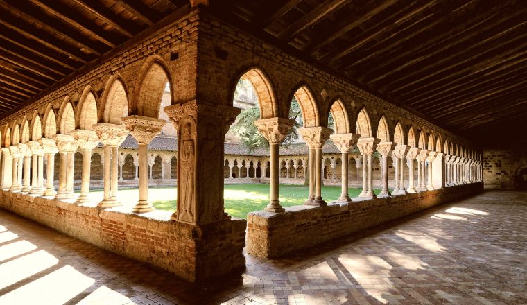
Day 11: Espeyrac – Conques, 13 km/8.1 miles.
Altitude at departure: 369m/1218ft.
A short stage, which is all to the good as the arrival at Conques, after walking through fields and woodland, is magical. The medieval quarter is visible only at the last moment to the pilgrim coming from the east; and the town extends awayin tiers of pointed roofs overlooked by the three towers of Basilica Sainte Foy. It is worth devoting as much time as possible to the discovery of this enchanting town.
Altitude at arrival: 280m/924ft. 3 hours 30.
Day 12: Conques – Decazeville, 20 km/12.5 miles.
Altitude at departure: 280m/924ft.
After the bridge over the Dourdou, the route climbs up the charming Chapel of St. Foy, with one last look at beautiful Conques. Soon after, you have a choice of shorter or longer routes to bring you to the old mining town of Decazaville.
Altitude at arrival: 225m/743ft. 4 hours 30.
Day 13: Decazeville – Figeac, 29 km/18.1 miles.
Altitude at departure: 225m/743ft.
A short climb to the Saint Roch chapel (353m/1165ft) and then down to the Lot Valley and on to Livinhac (220m/726ft), followed by a fairly strenuous climb into the Lot department and the aptly named village of Montredon (‘the roundmountain’). The route takes you then to Figeac with its historic centre.
Altitude at arrival: 194m/640ft. 9 hours.
Day 14: Figeac – Cajarc, 30 km/18.7 miles.
Altitude at departure: 194m/640ft.
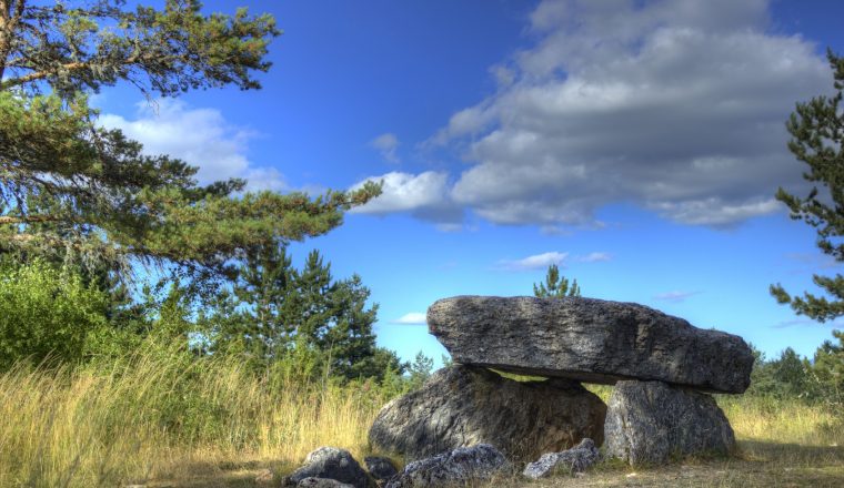
We reach Carjac by walking on the plateau that separates the Cele and Lot valleys. After Faycelles (319m/1053ft) and Beduer, the landscape changes. Menhirs and dolmens appear, along with charming dry-stone constructions which accompany us to Grealou (374m/1234ft) in the extreme south of the regional park of the Causses du Quercy; and then again into the valley of the Lot.
Altitude at arrival: 160m/528ft. 31.5 kms/19.7 miles. 8 hours 30.
Day 15: Cajarc – Limogne, 18 km/11.25 miles.
Altitude at departure: 160m/528ft.
Head southwards to cross a marshy plain in a meander of the River Lot to the lush pastures of Gaillac. Then it is up to the Causse de Limogne where stone is used for everything. Before reaching Limogne (famous for its truffle market), we pass by Mas de Pech (339m/1119ft) and the Mas de Borie.
Altitude atarrival: 300m/990ft. 4 hours 15.
Day 16: Limogne – Lalbenque, 24 km/15 miles.
Altitude at departure: 300m/990ft.
Continue across the Causse, skirting the village of Varaire and become one with the old Roman road (ancient paving stones still lie beneath the soil). At the D55, we leave the path to reach Lalbenque.
Altitude at arrival: 250m/825ft. 5 hours.
Day 17: Lalbenque – Cahors, 21 km/13.1 miles.
Altitude at departure: 250m/825ft.
There are a couple of options. Purists will return to the where they joined the D55, others will continue onwards via another path to join the main route further on. Then one more wild plateau before the descent into handsome Cahors.
Altitude at arrival: 122m/403ft. 4 hours 30.
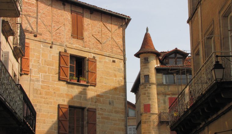
Day 18: Cahors – Montcuq, 31 km/19.4 miles.
Altitude at departure: 122m/403ft.
We finally leave the Lot Valley that we have been following on and off since Espalion, and head more directly south. Meanwhile, we scale the slopes above the river by means of steps and rungs (height difference of 200m); then the route stretches away across the fertile Quercy Blanc (a name derived from its chalky soil) to Montcuq and its distinctive fortress.
Altitude at arrival: 175m/577ft. 31 kms/19.4 miles. 7 hours 45.
Day 19: Montcuq – Durfort Lacapelette, 25.7 km/16 miles.
Altitude at departure: 175m/577ft.
Continue across Quercy to Lot and Garonne. We pass our first ‘bastide’ (fortified town), Lauzerte, isolated on its pinnacle (a worthwhile 2 km/1.25 mile detour) and, enjoying the pretty architecture of the region, head on to Durfort.
Altitude at arrival: 206m/680ft. 25.7 kms/16 miles. 6 hours 30.
Day 20: Durfort – Moissac, 14 km/8.75 miles.
Altitude at departure: 206m/680ft.
A short walk across fields and orchards bring us swiftly to Moissac, a lovely town on the banks of the Tarn that has always been an important halt on the Way of St. James. As well as the historic centre, it is worth having a look at the Canal Bridge, where the Garonne canal spans the river.
Altitude at arrival: 76m/251ft. 14 kms/8.75 miles. 3 hours 30.
Day 21: Moissac – Auvillar, 19.2 km/12 miles.
Altitude at departure: 76m/251 ft.
Our route today follows the canal towpath for the most part – a relaxing, tranquil day (unless you decide to take the higher path along the slopes above). Cross the bridge at Pommevic and head south to Auvillar.Altitude at arrival: 108m/356ft.19.2 kms/12 miles. 4 hours 45.Day 22: Auvillar – Lectoure, 33.1 km/20.7 miles.Altitude at departure: 108m/356ft. Soon we enter the Gers – pass Flamarens and its old castle, followed by Miradoux, the oldest bastide in the Gers, before reaching Castet Arrouy, where you have a choice of routes – the more direct route or the old route via Avit Frandat (191m/630ft).
Altitude at arrival: 186m/614ft. 33.1 kms/20.70 miles. 8 hours.
Day 22: Auvillar – Lectoure, 33.1 km/20.7 miles.
Altitude at departure: 108m/356ft.
Soon we enter the Gers – pass Flamarens and its old castle, followed by Miradoux, the oldest bastide in the Gers, before reaching Castet Arrouy, where you have a choice of routes – the more direct route or the old route via Avit Frandat (191m/630ft).
Altitude at arrival: 186m/614ft. 33.1 kms/20.70 miles. 8 hours.
Day 23: Lectoure – La Romieu, 19 km/11.9 miles.
Altitude at departure: 186m/614ft.
Initially head west, passing Marsolan (171m/564ft) and then the chapel at Abrin, at which point the route goes northwards for La Romieu. This is not the historic route (pilgrims would in the past have headed directly for Condom) but La Romieu, with its collegiate church of St. Peter, served as a staging post for pilgrims coming from Rocamadour and Agen and it is where we pass the night.
Altitude at arrival: 167m/551ft. 19 kms/11.9 miles. 4 hours 45.
Day 24: La Romieu – Condom, 16 km/10 miles.
Altitude at departure: 167m/551ft.
A short section to Condom, via Castelnau sur L’Auvignon, and the old Romanesque chapel of St. Germaine. Conoisseurs may like to try a glass of Armagnac, for which Condom is famous.
Altitude at arrival: 81m/267ft. 16 kms/10 miles. 3 hours 45.
Day 25: Condom – Montreal du Gers, 16.3 km/10.2 miles.
Altitude at departure: 81m/267ft.
Into the heart of Gascony, with its gastronomic and rural traditions. It is worth making a short detour to Larresingue and its ramparts, before crossing the Osse via the ancient bridge at Artigues and heading to Montreal, ancient bastide overlooking the Auzoue.
Altitude at arrival: 135m/446ft. 16.3 kms/10.2 miles. 4 hours.
Day 26: Montreal du Gers – Eauze, 16.3 km/10.2 miles.
Altitude at departure: 135m/446ft.
The route heads due south across country. From Lamothe (167m/551ft) the path is along the former railway line, guaranteeing good, easy walking.
Altitude at arrival: 142m/469ft. 16.3 kms/10.2 miles. 4 hours.
Day 27: Eauze – Nogaro, 20km/12.5 miles.
Altitude at departure: 142m/469ft.
Today, undulating landscapes, vineyards, fields of maize, forests…half way is Manciet, the old meeting point of the Via Podiensis and the route from Auch.
Altitude at arrival: 98m/323ft. 20 kms/12.5 miles. 5 hours.
Day 28: Nogaro – Aire-sur-Adour, 30 km/18.75miles.
Altitude at departure: 98m/323ft.
Gradually the landscape changes from woodland to, in the Landes department, the Adour plain. A curiosity here are the dovecotes hidden in the treetops.
Altitude at arrival: 81m/267ft. 30 kms/18.75 miles. 7 hours.
Day 30: Aire-sur-Adour – Miramont Sensacq
Day 31: Walk Miramont Sensacq – Arzacq
Day 33: Walk Pomps– Maslacq
Day 34: Walk Maslacq – Navarrenx
Day 35: Walk Navarrenx – St Palais
Day 36: Walk St Palais – Larceveau
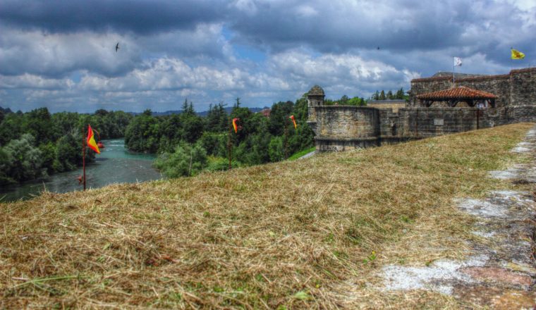
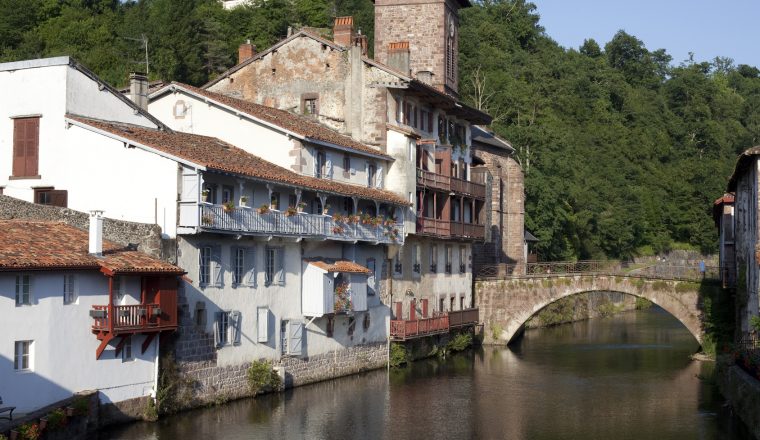
Day 37: Larceveau – St Jean Pied de Port
Day 38: End of the trip after breakfast.
ACCOMMODATION
We book family run hotels – 2 and 3 star and guest houses, all rooms with private bathroom.
Dinner and breakfast are included each day.
ARRIVAL AND DEPARTURE
There is a train station in Le Puy with good connections to Lyon and Clemond Ferrand – and on to Paris.
The walk finishs in St Jean Pied de Port. Nearest airport is Biarritz – bus from St Jean to the airport.
Or train to Bayonne and good connections throughout France.